How to Fix DC’s Bus Numbers While Minimizing Confusion
DC’s bus routes are being redrawn—and renumbered. Instead of starting from scratch, building on the existing numbers could ease the transition.
You probably don’t think about bus route naming and numbering very often. Today is the day that changes!
Washington, DC’s main transit agency is redrawing its bus network, which provides a strategic opportunity to clean up what is currently a confusing mess of different route names. The most recent proposal is a huge step forward—but will require everyone to learn new routes from scratch.
What if there’s a creative alternative naming system that achieves the same goals but with significantly less disruption by leveraging the best of the current system?
Great news: There is. Let’s get rolling!
The current mess
WMATA is the largest transit agency in the Washington, DC region—running almost all buses in the central city and some in the suburbs. For historical reasons, their routes have three different naming schemes:
Just a number (e.g. 42, 70)
A letter + number (e.g. H4, J2)
A number + letter (e.g. 16M, 38B)
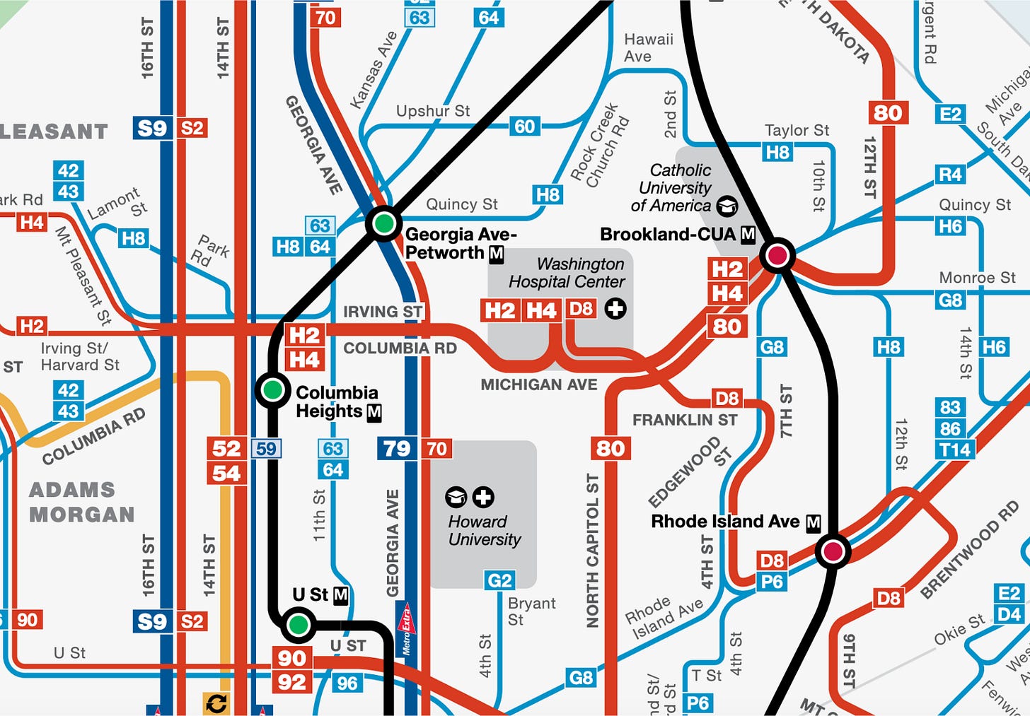
You might say “So what?” But this stuff really does matter! Noted transit planner Jarrett Walker explains:
Numbers, like words, never just refer. They also connote. You can refer to a particular bus route as F, 9, J2, 76, or 239K, but those numberings will inevitably convey subliminal messages about those services, especially in relation to the other numbers around them. “239K” for example, connotes that “this is a really complicated network, where you deal with details even to remember a line number, let alone figure out the service.” Likewise, if you see a long segment served by lines 121, 123, 124, and 127, the connotation is that the 120s represent some kind of pattern that might be useful in understanding the service. It's almost impossible not to refer to this segment as “the 120s”.
After moving to DC, I was quite confused by the different naming schemes. Did they represent different types of service (e.g. local vs. limited-stop), fares, or destinations? Nope—just historical holdovers! I got used to it, but it’s still odd and can confuse new users.
Cleaning things up
WMATA is redrawing the region’s bus routes to improve the system and using the opportunity to simplify route names. I’m excited!
(By “name” I mean an entire set of numbers and/or letters, and “number” just for the numerical part; e.g. “L2” is a name, “2” is its number.)
In the most recent proposal, all route names start with a letter—referring to the main city or county it runs in—followed by a two-digit number (e.g. “D22”) or, for limited-stop routes, a one-digit number and “X” (e.g. “D2X”). Here’s a full map of DC, and more info.
In DC proper, route numbers would go counterclockwise around the city, from the 10s in the southeast to the 90s in the northwest. Some routes would start with “D” and others with “C.”
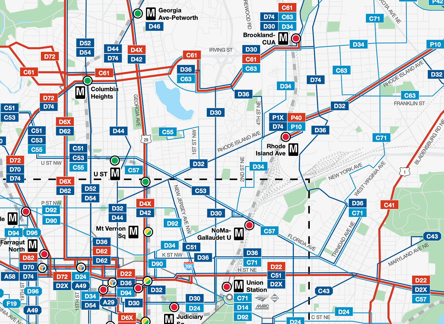
If you’re not from DC, you might not think much.
If you are from DC, you might notice something odd: A bunch of route numbers are being flipped.
There’s a deeper story here.
The status quo isn’t entirely a mess
Beneath what looks like the chaos of the current naming system, there’s a logic.
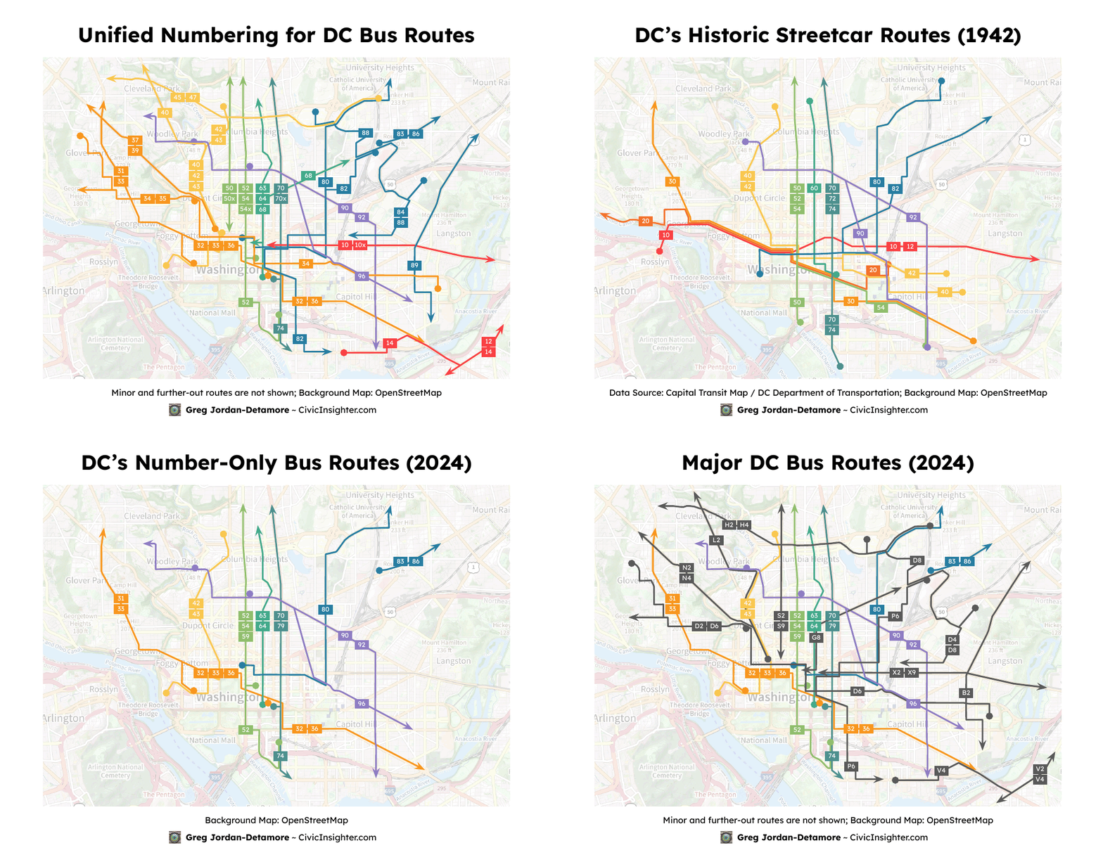
Look closely at the current map again. Going from west to east, there’s a series of routes with increasing numbers:
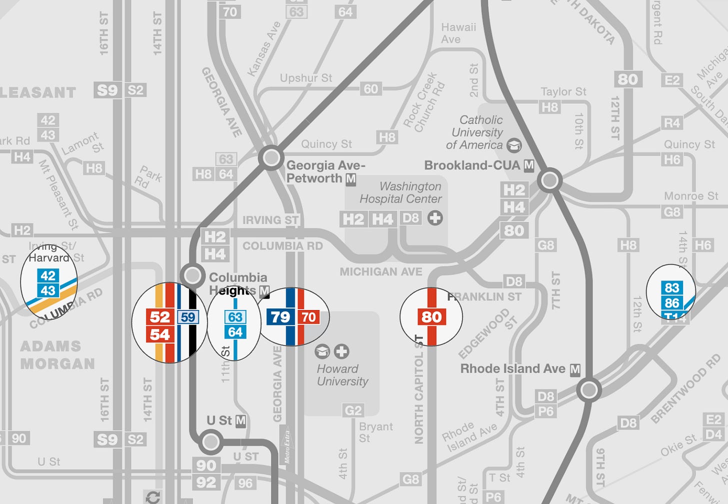
If we put aside the letter+number routes and just look at the numbered routes, they’re neatly numbered from west to east, going from the 30s through the 80s. The 10s and 20s aren’t used, and the 90s cut across.
This dates back to 1936! Streetcar routes were numbered clockwise, starting with east-west route numbers in the 10s and 20s, southeast-northwest routes in the 30s and 40s, and so on through the 80s, plus the 90s cutting across.
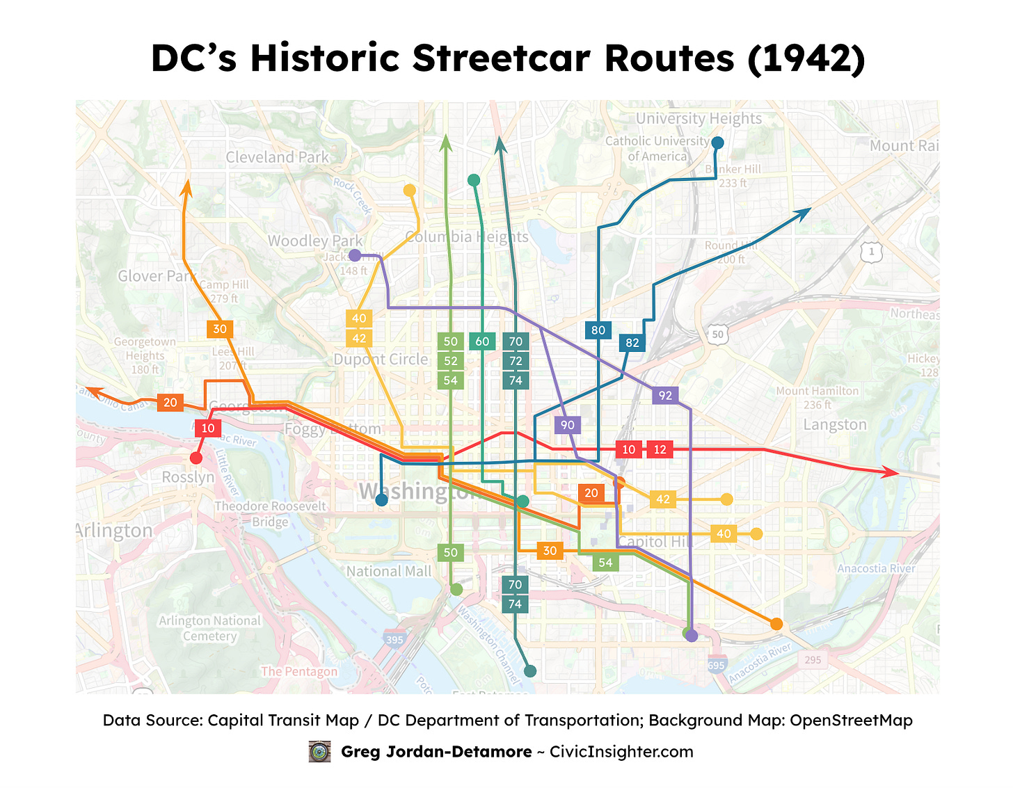
Over the years, new transit routes have been added—most using a “letter+number” format—leading us to today’s system:
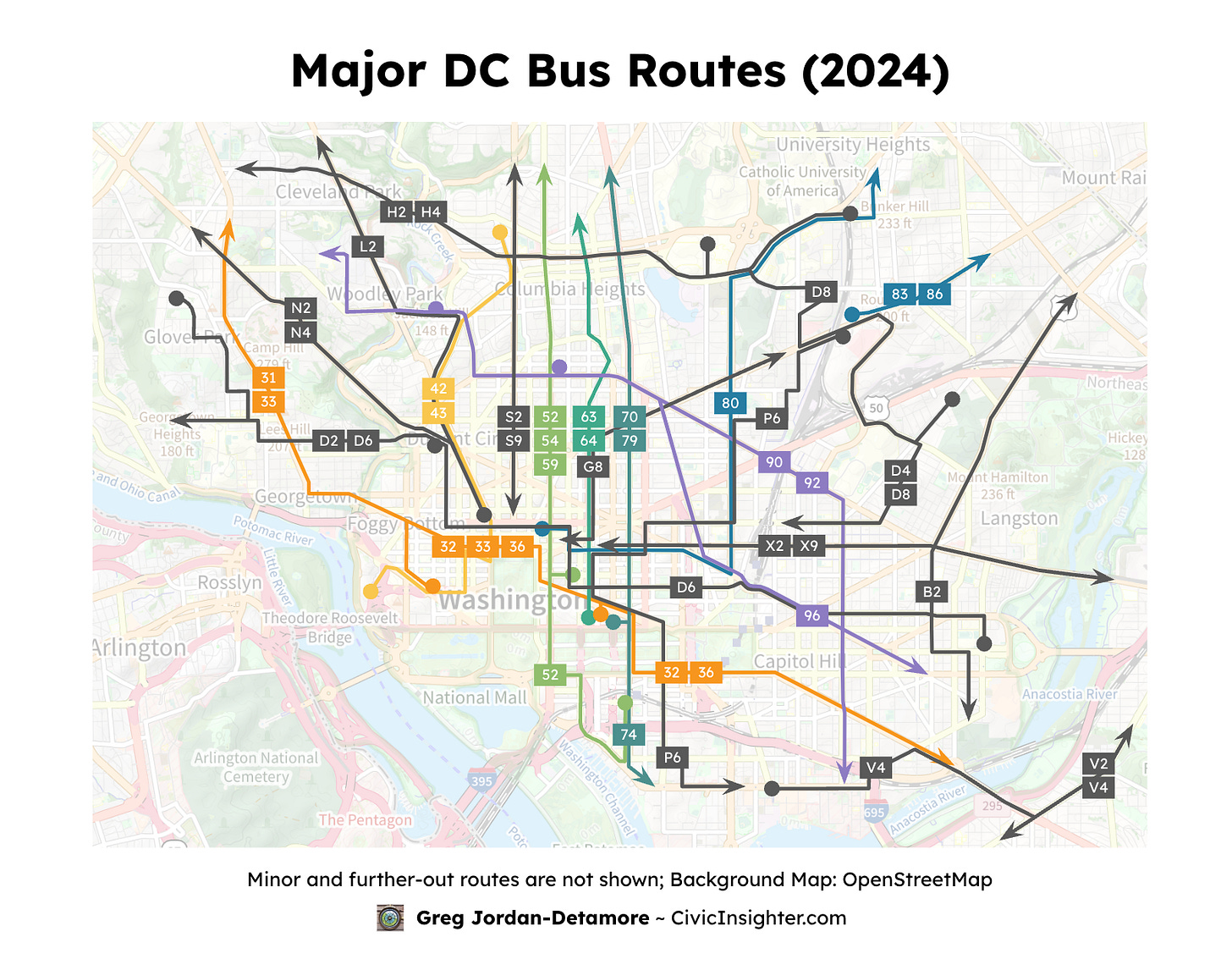
You can still see the “bones” of the historic numbering system underneath the chaos.
Why does WMATA’s proposal seem to swap so many route numbers? The centerpiece of the plan is to flip the entire numbering system from the current (and historic) clockwise system to one that’s counterclockwise. Imagine a simplified diagram of routes radiating out from the city center:
Is this big flip really necessary?
As an abstract matter: I don’t see any major reason why counterclockwise is superior. If anything, clockwise numbering has the benefit of most routes increasing in number as you read a map from left to right, the same direction you read text in English and most other languages.
As a practical matter: People have become familiar with the existing system over decades; asking everyone to tear up their mental maps is a very heavy lift.
Moving forward by keeping what works
Here’s an alternative idea: Maintain the route renaming’s stated goal of having a clean, geographic numbering system—but implement it by keeping the current clockwise numbering system and adapting the letter+number routes to match it. It could look like this:
For example: The L2 becomes the 40, as it’s between the 33 and 42. The S2 becomes the 50, as it’s between the 43 and 52. Though some route numbers will change, they align with familiar numbers, and many routes stay the same.
Here’s an animation:
(Here’s a slower version and one with only the before-and-after of current vs. unified.)
Two more issues emerge:
Crosstown: The clockwise system works for routes to/from downtown, but what about those that go perpendicular (“crosstown”)? Since most of them only serve a certain sector of the city, I numbered them to match other routes in the same area.
East of the Anacostia River: The river forms a large natural barrier, so many routes connect to rail stations rather than going downtown. I put these routes in the 10s and 20s, as those numbers aren’t currently used; this also keeps to the historic clockwise numbering system.
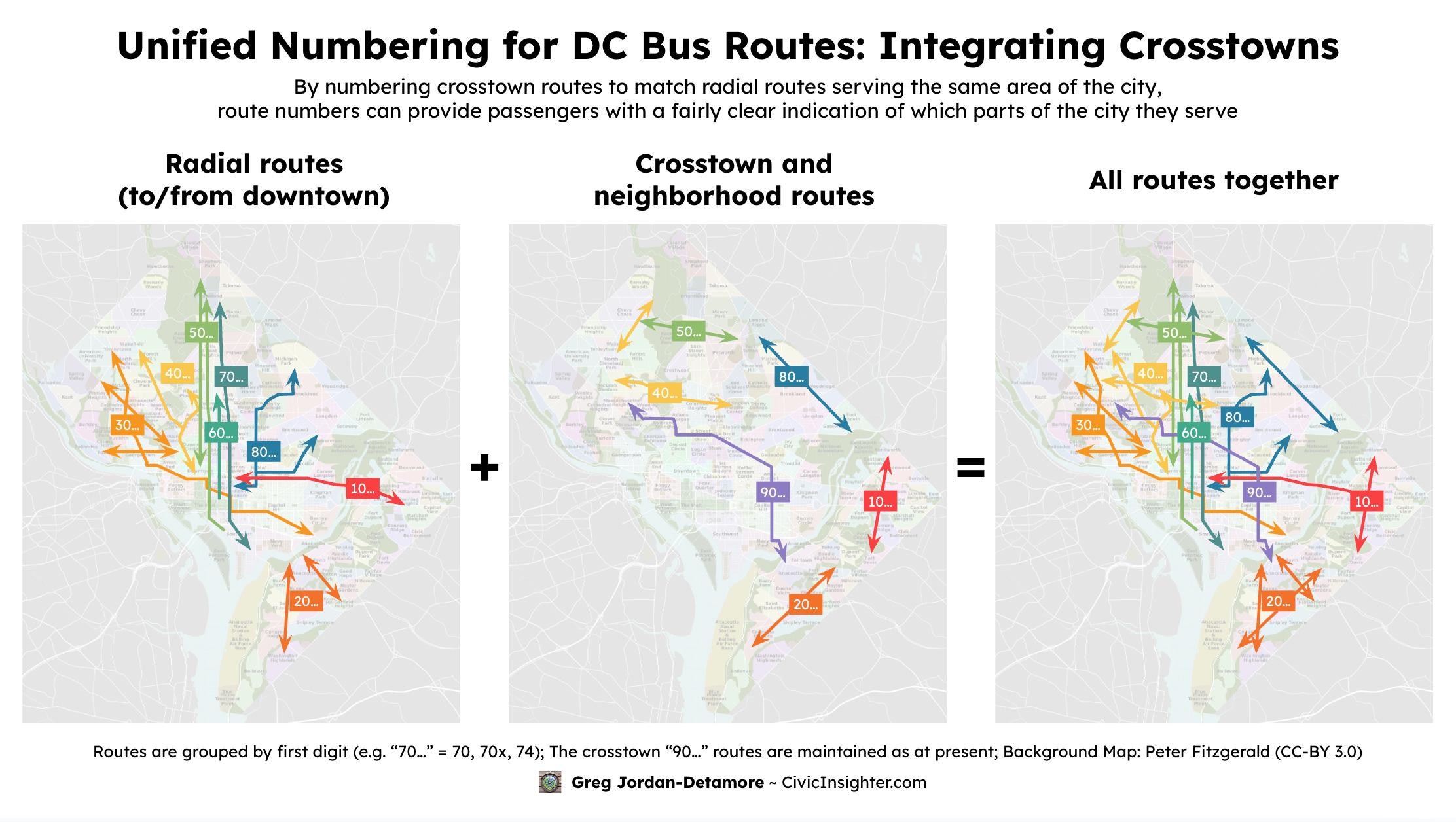
I based these images on existing routes because the new routes aren’t yet final. But much of the proposed network resembles the current one, and the principles I outlined here can be applied to whatever final route network WMATA selects. To show this, I took the draft map that WMATA released earlier this year and renumbered all the DC routes:
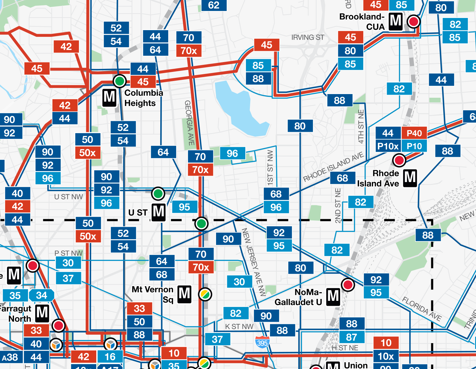
Check out the full map and a spreadsheet with route-by-route name justifications. (I submitted a version of this map during the public-comment period in July.)
‘X’ marks the spot
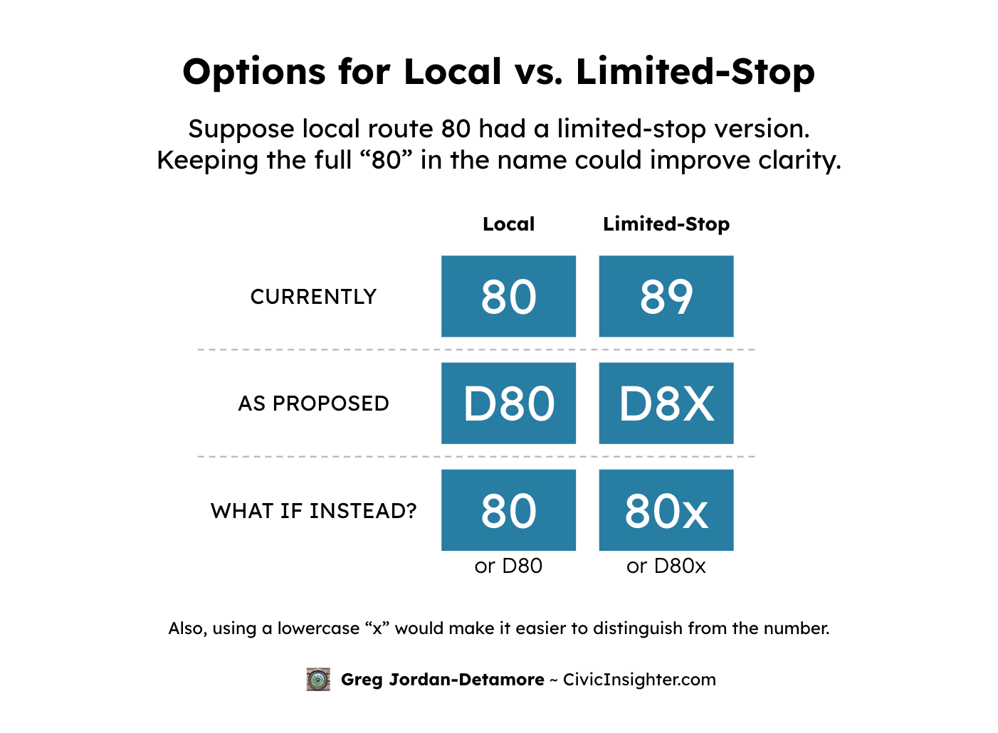
Currently, limited-stop route numbers take the corresponding local route and swap in a “9” as the last digit. 70 becomes 79, S2 becomes S9, and so on.
New riders can easily miss this. So WMATA’s proposal—which I support—is to use an “X” instead.
But one tweak would make things easier to understand: putting the “x” after the number, rather than replacing the last digit. So, the limited-stop 70 would be the 70x, not 7X. This clarifies which route is being referenced, and is the method used in cities like New York (e.g. B46, B46 SBS) and San Francisco (e.g. 38, 38R).
Speaking of letters….
D and C
WMATA’s proposed route naming scheme introduces a clever idea: using letters to indicate which city or county a bus primarily serves. For example, Montgomery County routes would start with “M” (e.g. “M62”).
This is also the system used for buses across NYC’s boroughs. I generally like it!
But there’s a wrinkle with DC: They propose using both the letters “D” and “C”:
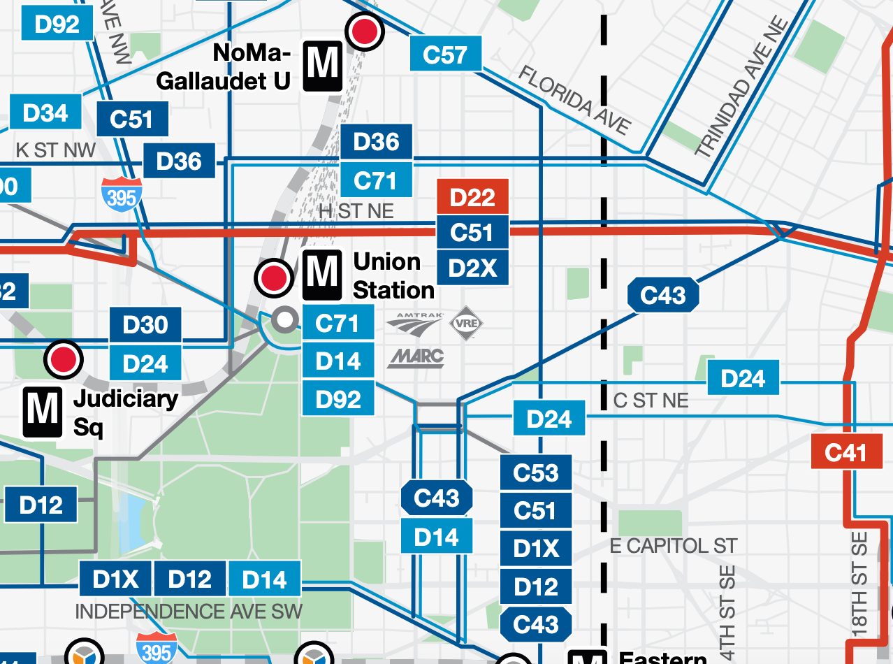
The idea is that routes oriented to/from downtown get a “D” while crosstown routes get a “C.”
Philosophically it’s cool; in practice, it may cause more problems than it solves:
Undermines simplicity: The painful renaming of routes aims to create a simpler, more consistent naming system. “The letter = the jurisdiction, except in DC where two different letters are used based on another factor” undermines that.
Highlights an often-unimportant aspect: Many trips aren’t to/from downtown anyway—even on downtown-serving routes—so knowing whether the bus goes there doesn’t always add value. Also, many routes are squiggly, go toward downtown but not all the way, or go to the edge of downtown, making them hard to classify.
Adds mental burden: Needing to remember an extra character in the route name adds mental burden to the already-enormous task of getting to know the system.
A simpler alternative is to use even vs. odd numbers: even = route goes downtown, odd = crosstown. With a few exceptions, that’s already the case for WMATA’s proposed route numbers! And mine could easily be adapted. This way, the info is available for those who value it without forcibly burdening all users.
It would be much better to use just one letter, like “D.”
But why not go a step further and drop the letter altogether for DC routes—but keep it for suburban ones? Consider:
Simplicity for most: 70% of WMATA’s top bus routes by ridership primarily serve DC. Including a letter on DC routes adds unnecessary clutter for most passengers.
Highlighting the core: DC is the economic, cultural, and social heart of the region, so “DC vs. suburbs” is a meaningful distinction.
Already open to it: WMATA’s “C” vs. “D” proposal is already a “generally geographic, but DC is a slight exception” one.
Leaving the letter off DC routes while keeping it on suburban ones balances competing priorities: providing simplicity for most passengers while still providing geographic information.
Jarrett Walker writes:
[L]ower numbers feel simpler. Using lower route numbers in the central city, as many big regional agencies do, helps this core area, where ridership is highest, feel more navigable without reference to the more complex networks that the suburbs require.
I see “letters vs. no letters” as a variant of this.
Lessons from New York
In 2010, New York’s MTA proposed merging the historic “M” line with the newer “V” line, upsetting many riders.
So the MTA revised the plan, keeping the same route but naming it the “M”—garnering a much more positive public response!
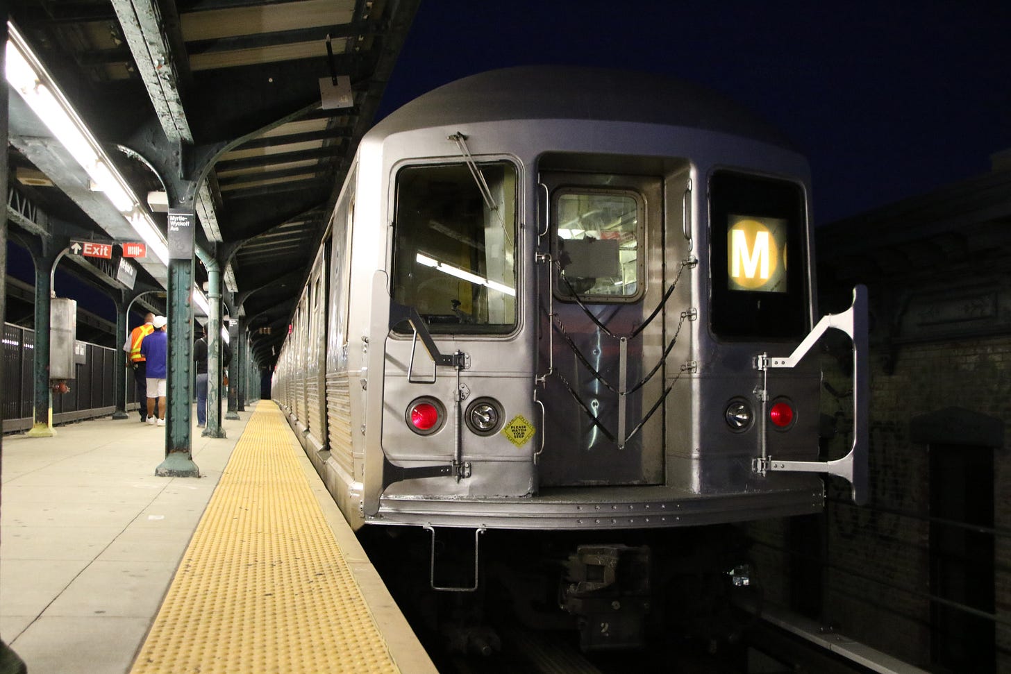
The New York Times reported:
The changes … were announced earlier this year. But the new route had been expected to be called the V, with the M train disappearing. An outcry at public hearings led transit planners to rethink the nomenclature.
“People were more comfortable with the M designation, being an older and more historic train designation than the V,” said Charles Seaton, a spokesman for New York City Transit. (The V was born in 2001; the M dates back decades.)
Explaining the change, the MTA wrote:
While some members of the community were supportive of the service pattern change, many people expressed objection to the elimination of the ‘M’ designation.
People are more comfortable using familiar names.
WMATA acknowledges this. In their video explaining the proposed new route names, they note:
You also told us that it’s hard to learn new bus route names from scratch, so it would be nice if new route names tied back to existing names.
We have an opportunity to do just that!
The route ahead
So here’s the deal:
The status quo of bus naming is a mess.
The effort to clean things up is exciting, and a lot of great effort is going into it!
The specific most-recent proposal is going to cause an unnecessary level of disruption and chaos.
There’s an alternative way to achieve the same goals but with a much smoother transition.
This alternative naming scheme is to:
Keep what works (the numbered routes) and only change what needs fixing (the letter+number routes)
Rename routes using the existing clockwise geographic numbering system, helping people understand the new names using ones they already know
Use no letter, or just one letter (e.g. “D”), at the start of DC routes—but don’t mix “D” and “C”
Signal limited-stop routes by adding an “x” at the end of the full route number, rather than replacing the last digit
I love WMATA and am hoping for the best with the renaming and the network redesign overall. I would not have thought of these ideas unless I had the existing proposals to react to, so I thank them tremendously!
With any luck, some version of this proposal can help smooth the transition to the new bus network. And when it’s done, people will finally be able to form an easy mental map of DC’s bus system—without needing to re-learn every route from scratch.
—
What do you think? Leave a comment below!
If you live in DC and think some version of this is a good idea, reach out to your councilmembers and ANC commissioners today.
Finally, subscribe to get my upcoming posts straight in your inbox!


